
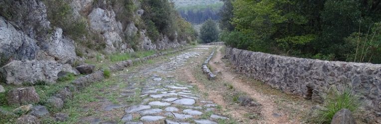
The Regina Viarum, among all ancient roads, is the richest in memories and testimonies. Also defined by the Latin authors as insignis nobilis, celeberrima, it soon became in fact the unsurpassed model of the road system that from Rome lead to the furthest regions ofthe world known at that time. The Appian Way was in fact the first arterial of а complex and articulate road system, which is still the base of the modern road network, and instrument of great communication.
The Appian is probably the most visionary among the great ancient enterprises, which shaped the Italian landscape. Planned in order to connect Rome to the ancient Capua, (Saint Maria Capua Vetere) in the midst of the second Sanmite war, had since the beginning a great political meaning. It had to respond, in fact, to the need of Rome to progressively expand its power into the Southern regions and lay the foundation for the Empire.
The gradual extension ofthe Appian road signed the increasing subjugation of the territory: after the deduction of the colony in Venusia in 291 b.C. the Conquest of Taranto and Sannio in 272 and the foundation in 268 b.C of the Latin colony of Beneventitun, started the road extension to Taranto with the aim of the reaching Brundisium, bridgehead towards the Est, where in fact the colony was deducted between 246 and 243 B.C. in the visionary intent of expansion beyond the Mediterranean.
Since it had political and military value it had a pivotal role trough is blueprint on the territory. lt was an important point of reference in the distribution of the land among the veterans according to the established criteria of the centuriation. It was an element of regulation and aggregation of urban settlements, of which often was decumanus.
The Appian continued to function at least until the sixth century A.D. as told by Procopio of Cesarea, in his treatment of the Gothic war. During the medieval time it lost its status as a long distance artery and was divided into many small local entities. It had, however, а fundamental role for the pilgrims paths to the Holy Land during the Crusades, once again proved its military importance and its role as intermediary of important cultural exchanges, as demonstrated by the Oriental influences found in the religious and urban architecture ofthe Southern regions.
It had moments of plundering and looting and moments of monumental splendour, especially entering or exiting the cities. For example, a monumental gate was set up at the entrance of Capua, at the time of Federico ll and in the nineteenth century a grand appearance was awarded on initiative of the Papal State in the first leg leaving from Rome.
When at the beginning of the century, under French rule, the commercial activities of the Southern territories began to increase, there was the need to speed up transport and trade, so the road network was reorganized for explicit. decree of Gioacchino Murat, the Appian experienced a new period of great fortune, which further increased with the Bourbon restoration.
After the Italian Unification, in 1887, the Ministers Guido Baccelli and Ruggero Bonghi launched, unfortunately without success, the first recovery projects of the Ancient Appian, aiming at the protection of the entire route from Rome to Brindisi.
lts survival was really endangered only during the last century, by the post war urban development, the abandonment ofthe countryside, the industrialization of the territories and the increase of road network, which often dispersed it perception among the squalor and the disorder of the outskirts.
In 1955 during the boom of the construction industry, Umberto Zanotti Bianco, as a Senator and President ofthe Commission for territorial protection and landscape of the Appian Way, supported the need to preserve, even if restricted to the first section between Rome and Marino “the archaeological and andscape needs” of the band crossed by the ancient road “beyond the urban” if not in contrast with the first.
All the latest events related to the Appian Way refer cases of archaeological and landscape protection of the Roman section, not always successfully concluded; the incessant attempts to overbuild were opposed by a group ofarchitccts, urban planners, journalists, intellectuals guided by the tireless work of condemnation of Antonio Cederna and the cultural association ltalia Nostra, in 1984 “A Plan for the Ancient Appian Park” was drafted, for the area between Porta San Sebastiano and the Frattocchie.
Only in I988 the Lazio Region approved the institution of the Appia Аntiса Regional Park. In 1993 Cederna was appointed President of the consortium for the Appia Antica Park.
The two Government bills presented between 2003 and 2004 (XIV Legislature), respectively 11.2571 by initiative of Senator Bordon and others, and 11.2628 by initiative of Senator Specchia and others, both bearing “Rules for the enhancement of the Appian in the entire route from Rome to Brindisi”, have not been successful.
ln 2010, the Magna Graecia Society, assuming the commitment of its founder Umberto Zanotti Bianco, carried out a study for the construction of an environmental policy project on the ancient Appian Way and its variants, most notably the Appia Traiana, and the modern set of these great ancient arteries, in particular with regard to the conservation, enhancement and upgrading not only ofthe route and sites that gravitate but also the landscape and environment they cross. With the Appia Regina Viarium project intervention methods are expected, above all through landscape and urban planning, ensuring a clear reading of the ancient path and the persistence ofthe path in the modern Appian and Traiana road network, exalting the function of regulatory elements.
To this end, with an accurate and comprehensive bibliographic survey and archive, a data base was set up about the section between Garigliano and Brindisi and connected with a basic building block mapping for the ranking ofsites with a synthetic form of easy consultation.
The Project
The project to improve the ancient Appian Way by Mibact which already started with the Service I procedures for the registration of the historic road in the World Heritage List placed under the protection of UNESCO was based on the suggestions created by the journey of Paolo Rumiz and his companions taking into account the important document kit developed at that time.
The project will combine the protection and enhancement of the ancient Roman road, which has played a vital role in ancient times, keeping fora longtime its function as a connecting element between regions and cultures, and the promotion of new model of touristic finition through the construction of itineraries and circuits that can help the slow tourism and enhance the variety and complexity of the national offer.
The project is divided into two phases, subjected to the appropriate prerequisites of the first actions of the general approach, not necessarily developed in sequence but rather following the different degree of growth of the different activities in the different areas concerned.
The first phase had as its objective the precise identification of the track and all the evidence notes that will fall; we are now ready to design all the useful works to deliver the ancient Appian Way to full fruition. lt will therefore be necessary to ensure a clear reading of the ancient route and the persistence ofthe Ancient Appian way in modern road network.
To this end, it was possible to use the Geo Cultural HUB, the geographical reference system already in use at the Ministry of Education, which reports the path followed by Paolo Rumiz and his companions, integrated with the bulk of knowledge concerning the Roman road available at the Mibact structures and generally produced by the scientific community. The Data Base edited by the Magna Graecia Society is therefore finding its ideal application.
The route which will be promoted, is available on the web portal, identifying the archaeological, historical, architectural, naturalistic evidence present along the itinerary, the sections already accessible and the necessary variations to the ancient route that will be offered.
“Alternative” traits to the original route will also be available, in particular where the Appia result affected by intense flows of vehicular traffic or where the details of the orographic characters allow the possibility to take a “look” from above, also using new technologies such as drones for filming/photographic of entire route and alternative not accessible routes.
The Geo-Cultural HUB therefore constitutes the basic instrument and the qualifying and dynamic element of the project available to all the partners called to share its realization. The size and complexity ofthe initiative, in fact, means that it must be a Collective work, on which different institutional levels converge, the Mibact with its central and local bodies, local authorities, regions and municipalities, and other institutions.
Therefore the technical board specifically instituted indicates the stature of this project, as it offers the opportunity to its members, institutions and experts, to share criteria and methods of intervention, according to agreed protocols on how to implement the various operations of maintenance and restoration, by enhancing the promotion and dissemination, according to the landscape and urban planning already in place or to be planned.
The Geo—cultural HUB, already operational and constantly updated, allows focusing on emergencies and priorities and allows the timely programming the interventions and management of the different compartments.
Moreover, it will constitute the interactive basis for the documentation required to the inclusion in the UNESCO list for both the production of thematic maps and for the definition of the buffer zone and finally for the preparation of the management plan. With the presence of a DataBase interconnected with the georeferenced cartography it is possible to develop an extensive program of interventions aimed on the one hand at identifying a coincident or neighbour path to the Appian path and, on the other, to prepare, according to shared criteria, strategies for the protection, recovery, restoration and enhancement not only of the way but also the suburban and urban landscape that follows and retains the imprint.
The great opportunity of a shared table of work, where all those who are engaged in the Appia conservation can put in place their own expertise and experience, from that of the Way, to raising awareness, to research, protection, conservation and restoration, to that of the redevelopment and reorganization of the territory, that accompanies the ancient road will allow to develop an ambitious but certainly feasible program of action, which safeguarding the specificity of the territories is aimed at enhancing the Appian as an itinerary and as relevant archaeological testimonial.
The ambitious goal is that the Appia will return to have a regenerative action for the landscape.
Luigi Scaroina
Archeological Officer Department II – MiBACT
Strategic national and community programming
